“Water” has since been detected inside the minerals in lunar rocks. Water ice has also been discovered to be mixed in with lunar dust grains in cold, permanently shadowed regions near the lunar poles.
But scientists haven’t been sure how much of this water is present as “molecular water”—made up of two parts hydrogen and one part oxygen (H2O). Now two new studies published in Nature Astronomyprovide an answer, while also giving an idea of how and where to extract it.
To date, the company has launched over 800 satellites and (as of this summer) is producing them at a rate of about 120 a month. There are even plans to have a constellation of 42,000 satellites in orbit before the decade is out.
However, there have been some problems along the way, as well. Aside from the usual concerns about light pollution and radio frequency interference (RFI), there is also the rate of failure these satellites have experienced. Specifically, about 3% of its satellites have proven to be unresponsive and are no longer maneuvering in orbit, which could prove hazardous to other satellites and spacecraft in orbit.
In order to prevent collisions in orbit, SpaceX equips its satellites with krypton Hall-effect thrusters (ion engines) to raise their orbit, maneuver in space and deorbit at the end of their lives. However, according to two recent notices SpaceX issued to the Federal Communications Commission (FCC) over the summer (mid-May and late June), several of their satellites have lost maneuvering capability since they were deployed.
Unfortunately, the company did not provide enough information to indicate which of their satellites were affected. For this reason, astrophysicist Jonathan McDowell of the Harvard-Smithsonian Center for Astrophysics (CfA) and the Chandra X-ray Center presented his own analysis of the satellites’ orbital behavior to suggest which satellites have failed.
The analysis was posted on McDowell’s website (Jonathan’s Space Report), where he combined SpaceX’s own data with U.S. government sources. From this, he determined that about 3% of satellites in the constellation have failed because they are no longer responding to commands. Naturally, some level of attrition is inevitable, and 3% is relatively low as failure rates go.
But every satellite that is incapable of maneuvering due to problems with its communications or its propulsion system creates a collision hazard for other satellites and spacecraft. As McDowell told Business Insider:
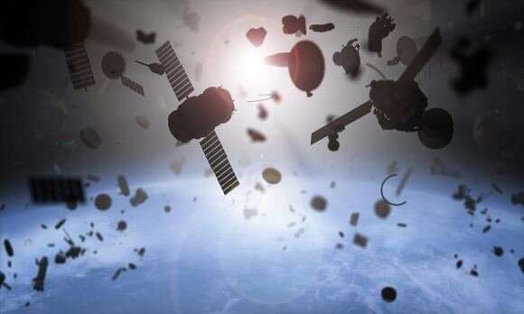
Artist’s impression of the orbital debris problem. Credit: UC3M
“I would say their failure rate is not egregious. It’s not worse than anybody else’s failure rates. The concern is that even a normal failure rate in such a huge constellation is going to end up with a lot of bad space junk.”
Kessler syndrome
Named after NASA scientists Donald J. Kessler, who first proposed it in 1978, Kessler syndrome refers to the threat posed by collisions in orbit. These lead to catastrophic breakups that create more debris that will lead to further collisions and breakups, and so on. When one takes into account rates of failure and SpaceX’s long-term plans for a “megaconstellation,” this syndrome naturally rears its ugly head.
Not long ago, SpaceX secured permission from the Federal Communications Commission (FCC) to deploy about 12,000 Starlink satellites to orbits ranging from 328 km to 580 km (200 to 360 mi). However, more recent filings with the International Telecommunications Union (ITU) show that the company hopes to create a megaconstellation of as many as 42,000 satellites.
In this case, a 3% failure rate works out to 360 and 1,260 (respectively) 250 kg (550 lbs) satellites becoming defunct over time. As of February of 2020, according to the ESA’s Space Debris Office (SDO), there are currently 5,500 satellites in orbit of Earth—around 2,300 of which are still operational. That means (employing naked math) that a full Starlink megaconstellation would increase the number of non-functioning satellites in orbit by 11% to 40%.
The problem of debris and collisions looks even more threatening when you consider the amount of debris in orbit. Beyond non-functioning satellites, the SDO also estimates that there are currently 34,000 objects in orbit measuring more than 10 cm (~4 inches) in diameter, 900,000 objects between 1 cm to 10 cm (0.4 to 4 in), and 128 million objects between 1 mm to 1 cm.
A team of astronomers from the University of Hawaiʻi at Mānoa’s Institute for Astronomy (IfA) has produced the most comprehensive astronomical imaging catalog of stars, galaxies, and quasars ever created with help from an artificially intelligent neural network.
The group of astronomers from the University of Hawaiʻi at Mānoa’s Institute for Astronomy (IfA) released a catalog containing 3 billion celestial objects in 2016, including stars, galaxies, and quasars (the active cores of supermassive black holes).
[…]
he results of their work have been published to the Monthly Notices of the Royal Astronomical Society.
Their PS1 telescope, located on the summit of Haleakalā on Hawaii’s Big Island, is capable of scanning 75% of the sky, and it currently hosts the world’s largest deep multicolor optical survey, according to a press release put out by the University of Hawaiʻi. By contrast, the Sloan Digital Sky Survey (SDSS) covers just 25% of the sky.
[…]
“Utilizing a state-of-the-art optimization algorithm, we leveraged the spectroscopic training set of almost 4 million light sources to teach the neural network to predict source types and galaxy distances, while at the same time correcting for light extinction by dust in the Milky Way,” Beck said.
These training sessions worked well; the ensuing neural network did a bang up job when tasked with sorting the objects, achieving success rates of 98.1% for galaxies, 97.8% for stars, and 96.6% for quasars. The system also determined the distances to galaxies, which were at most only off by about 3%. The resulting work is “the world’s largest three-dimensional astronomical imaging catalog of stars, galaxies and quasars,” according to the University of Hawai’i.
“This beautiful map of the universe provides one example of how the power of the Pan-STARRS big data set can be multiplied with artificial intelligence techniques and complementary observations,” explained team member and study co-author Kenneth Chambers.
[…]
The new catalog, which was made possible by a grant from the National Science Foundation, is publicly available through the Mikulski Archive for Space Telescopes. The database is 300 gigabytes in size, and it’s accessible through multiple formats, including downloadable computer-readable tables.
This survey has already yielded some interesting science, including an explanation for a rather spooky region of space known as the Cold Spot. Using the PS1 telescope, and also NASA’s Wide Field Survey Explorer satellite, the Pan-STARRS scientists spotted a massive supervoid—a “vast region 1.8 billion light-years across, in which the density of galaxies is much lower than usual in the known universe,” as the University of Hawai’i described it five years ago. It’s this supervoid that is causing the Cold Spot, as it’s seen in the cosmic microwave background, according to the researchers.
. The Transiting Exoplanet Survey Satellite (TESS), which launched in 2018, has snapped hundreds of thousands images of the night sky using its four cameras in the hopes of finding exoplanets. That’s too much data for professional astronomers to pore over, and NASA doesn’t trust computer-vision algorithms to do all the work, so they’ve decided to look to the public for help.
“Automated methods of processing TESS data sometimes fail to catch imposters that look like exoplanets,” said project leader Veselin Kostov, a research scientist at NASA’s Goddard Space Flight Center, and the SETI Institute. “The human eye is extremely good at spotting such imposters, and we need citizen scientists to help us distinguish between the look-alikes and genuine planets.”
[…]
A similar scheme called Planet Hunters TESS, run by the University of Oxford, led to a graduate student finding a binary-star planet at the start of the year.
“Planet Hunters TESS asks volunteers to look at light curves, which are graphs of stars’ brightness over time,” Marc Kuchner, the citizen science officer for NASA’s Science Mission Directorate, noted. “Planet Patrol asks them to look at the TESS image directly, although we plan to also include light curves for those images in the future.”
A study of comet motions indicates that the solar system has a second alignment plane. Analytical investigation of the orbits of long-period comets shows that the aphelia of the comets, the point where they are farthest from the Sun, tend to fall close to either the well-known ecliptic plane where the planets reside or a newly discovered “empty ecliptic.” This has important implications for models of how comets originally formed in the solar system.
In the solar system, the planets and most other bodies move in roughly the same orbital plane, known as the ecliptic, but there are exceptions such as comets. Comets, especially long-period comets taking tens-of-thousands of years to complete each orbit, are not confined to the area near the ecliptic; they are seen coming and going in various directions.
[…]
The solar system does not exist in isolation; the gravitational field of the Milky Way galaxy in which the solar system resides also exerts a small but non-negligible influence
[…]
hen the galactic gravity is taken into account, the aphelia of long-period comets tend to collect around two planes. First the well-known ecliptic, but also a second “empty ecliptic.” The ecliptic is inclined with respect to the disk of the Milky Way by about 60 degrees. The empty ecliptic is also inclined by 60 degrees, but in the opposite direction. Higuchi calls this the “empty ecliptic” based on mathematical nomenclature and because initially it contains no objects, only later being populated with scattered comets.
Future moon explorers will be bombarded with two to three times more radiation than astronauts aboard the International Space Station, a health hazard that will require thick-walled shelters for protection, scientists reported Friday.
China’s lander on the far side of the moon is providing the first full measurements of radiation exposure from the lunar surface, vital information for NASA and others aiming to send astronauts to the moon, the study noted.
[…]
Astronauts would get 200 to 1,000 times more radiation on the moon than what we experience on Earth—or five to 10 times more than passengers on a trans-Atlantic airline flight, noted Robert Wimmer-Schweingruber of Christian-Albrechts University in Kiel, Germany.
“The difference is, however, that we’re not on such a flight for as long as astronauts would be when they’re exploring the moon,” Wimmer-Schweingruber said in an email.
Cancer is the primary risk.
“Humans are not really made for these radiation levels and should protect themselves when on the moon,” he added.
[…]
Wimmer-Schweingruber said the radiation levels are close to what models had predicted. The levels measured by Chang’e 4, in fact, “agree nearly exactly” with measurements by a detector on a NASA orbiter that has been circling the moon for more than a decade, said Kerry Lee, a space radiation expert at Johnson Space Center in Houston.
“It is nice to see confirmation of what we think and our understanding of how radiation interacts with the moon is as expected,” said Lee, who was not involved in the Chinese-led study.
[…]
The German researchers suggest shelters built of moon dirt—readily available material—for stays of more than a few days. The walls should be 80 centimeters (about 2 1/2 feet) thick, they said. Any thicker and the dirt will emit its own secondary radiation, created when galactic cosmic rays interact with the lunar soil.
Yesterday, NASA and Russian flight controllers performed an “avoidance maneuver” to protect the International Space Station from a wayward chunk of space debris. This episode—already the third of its kind this year—highlights a growing problem and the importance of mitigating potential collisions in space.
Low Earth orbit (LEO) is vast and mostly empty, but when you have thousands upon thousands of objects zipping around at speeds over 6 miles per second (10 km/s), this space in space suddenly seems a lot smaller.
Such was the concern earlier this week when NASA, along with U.S. Space Command, detected an unknown piece of space debris that was expected to come uncomfortably close to the International Space Station. To safeguard the outpost and its crew, NASA and Russian flight controllers scheduled an impromptu “avoidance maneuver” to place the ISS out of harm’s way.
To do so, they fired thrusters belonging to Russia’s Progress 75 resupply spacecraft, which is currently docked to the Zvezda service module. Given the late notice, mission controllers had all three members of the Expedition 63 crew—Chris Cassidy, Anatoly Ivanishin, and Ivan Vagner—temporarily relocate to the Russian segment so they could be in close proximity to the Soyuz MS-16 spacecraft. NASA said this was done “out of an abundance of caution” and that “at no time was the crew in any danger.”
The piece of space junk was projected to pass to within 0.86 miles (1.39 kilometers) of the International Space Station, with the closest approach happening on Tuesday, September 22 at 6:21 pm EDT. The avoidance maneuver, which required just 150 seconds to complete, was performed about an hour earlier. NASA and Russian flight controllers worked in tandem to make it happen.
Once it was all over, the hatches between the U.S. and Russian segments were reopened and life resumed to normal.
Earlier this week, scientists announced the discovery of phosphine on Venus, a potential signature of life. Now, in an amazing coincidence, a European and Japanese spacecraft is about to fly past the planet – and could confirm the discovery.
On Monday, September 14, a team of scientists said they had found evidence for phosphine in the atmosphere of Venus. The region in which it was found, about 50 kilometers above the surface, is outside the harsh conditions on the Venusian surface, and could be a habitat for airborne microbes.
[…]
And as luck would have it, a joint mission comprising two spacecraft – one from the European Space Agency (ESA) and the other from the Japanese space agency (JAXA) – is about to fly past Venus that could tell us for sure.
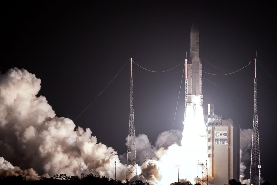
BepiColombo, launched in 2018, is on its way to enter orbit around Mercury, the innermost planet of the Solar System. But to achieve that it plans to use two flybys of Venus to slow itself down, one on October 15, 2020, and another on August 10, 2021.
BepiColombo launched on October 19, 2018.
AFP via Getty Images
The teams running the spacecraft already had plans to observe Venus during the flyby. But now, based on this detection of phosphine from telescopes on Earth, they are now planning to use both of these flybys to look for phosphine using an instrument on the spacecraft.
“We possibly could detect phosphine,” says ESA’s Johannes Benkhoff, BepiColombo’s Project Scientist. “But we do not know if our instrument is sensitive enough.”
The instrument on the European side of the mission, called MERTIS (MErcury Radiometer and Thermal Infrared Spectrometer), is designed to study the composition of the surface of Mercury. However, the team believe they can also use it to study the atmospheric composition of Venus during both flybys.
On this first flyby, the spacecraft will get no closer than 10,000 kilometers from Venus. That’s very far, but potentially still close enough to make a detection.
“There actually is something in the spectral range of MERTIS,” says Jörn Helbert from the German Aerospace Center, co-lead on the MERTIS instrument. “So we are now seeing if our sensitivity is good enough to do observations.”
Phosphine could be a biosignature of life in the Venusian atmosphere.
NASA/JPL-Caltech/Peter Rubin
As this first flyby is only weeks away, however, the observation campaign of the spacecraft is already set in stone, making the chance of a discovery slim. More promising is the second flyby next year, which will not only give the team more time to prepare, but also approach just 550 kilometers from Venus.
“[On the first flyby] we have to get very, very lucky,” says Helbert . “On the second one, we only have to get very lucky. But it’s really at the limit of what we can do.”
The International Space Station has served as the world’s most unique laboratory for two decades, hosting hundreds of scientific experiments, crews of astronauts and even the occasional slime.
But now, NASA, one of the space station’s primary operators, is preparing to oversee the largest push of business activity aboard the ISS. Later this month, up to 10 bottles of a new Estée Lauder (EL) skincare serum will launch to the space station, a NASA spokesperson told CNN Business. NASA astronauts are expected to film the items in the microgravity environment of the ISS and the company will be able to use that footage in ad campaigns or other promotional material.
The details of those plans were first reported by New Scientist magazine.
If the footage is used in a commercial, it would not be the first advertisement filmed in space; nor will it be the first time NASA has worked with corporate advertisers. But it will mark one of the most high-profile cases of NASA offering up the American portion of the space station for capturing zero-gravity footage of a product.
The Estée Lauder partnership will continue NASA’s years-long push to encourage private-sector spending on space projects as the space agency looks to stretch its budget beyond the ISS and focus on taking astronauts back into deep space. Those efforts include allowing the space station to be used for marketing and entertainment purposes.
An international team of astronomers, led by Professor Jane Greaves of Cardiff University, today announced the discovery of a rare molecule—phosphine—in the clouds of Venus. On Earth, this gas is only made industrially, or by microbes that thrive in oxygen-free environments.
[…]
finding that phosphine is present but scarce—only about twenty molecules in every billion.
The astronomers then ran calculations to see if the phosphine could come from natural processes on Venus. They caution that some information is lacking—in fact, the only other study of phosphorus on Venus came from one lander experiment, carried by the Soviet Vega 2 mission in 1985.
Massachusetts Institute of Technology scientist Dr. William Bains led the work on assessing natural ways to make phosphine. Some ideas included sunlight, minerals blown upwards from the surface, volcanoes, or lightning, but none of these could make anywhere near enough of it. Natural sources were found to make at most one ten thousandth of the amount of phosphine that the telescopes saw.
To create the observed quantity of phosphine on Venus, terrestrial organisms would only need to work at about 10% of their maximum productivity, according to calculations by Dr. Paul Rimmer of Cambridge University. Any microbes on Venus will likely be very different to their Earth cousins though, to survive in hyper-acidic conditions.
[…]
She comments: “Finding phosphine on Venus was an unexpected bonus! The discovery raises many questions, such as how any organisms could survive. On Earth, some microbes can cope with up to about 5% of acid in their environment—but the clouds of Venus are almost entirely made of acid.”
[…]
confirming the presence of “life” needs a lot more work. Although the high clouds of Venus have temperatures up to a pleasant 30 degrees centigrade, they are incredibly acidic—around 90% sulphuric acid—posing major issues for microbes to survive there.
Rocket Lab recently made a successful return to flight and launched a client satellite from its Electron Rocket, but that’s not all that happened on the mission. The company also secretly launched its own satellite, called Photon, that could one day fly ambitious deep space missions.
Photon is based on Rocket Lab’s “Kick Stage,” which is a mini rocket designed to boost satellite payloads into their final circular orbit once Electron has brought them to space. However, rather than just packing a propulsion system, Photon will carry additional electronics, orientation sensors, power generation units and instruments like cameras. That means that Photon can act as a satellite itself so that clients don’t need to contract third-party providers to design and build them.
Normally, once the Kick Stage does its job, Rocket Lab de-orbits it to burn up in the atmosphere. However, this time it sent a command that switched it into Photon satellite mode to continue on a standalone mission called “First Light.” Intended as a demonstration, it’s equipped with solar panels and a camera that can snap images of itself and the Earth.
Eventually, customers will be able to choose a “launch-plus-spacecraft” mission with the Electron Rocket and Photon satellite, which “eliminate[s] the complexity, risk and delays associated with having to build their own satellite hardware and procure a separate launch,” said Rocket Lab CEO Peter Beck in a statement.
During a press conference, Beck said that the company launched Photon in secret to “make sure it’s all good and it works before announcing it.” Rocket Lab said that a high-energy version of Photon will eventually fly “lunar and interplanetary missions,” including NASA’s Capstone mission in early 2021. In that mission, Photon will fly as a “pathfinder” that will help the Artemis program’s Gateway spacecraft safely approach the Moon.
In recent days, China has quietly launched a secret reusable spacecraft, left it in orbit for two days and safely landed it back on Earth. And although the spacecraft is top secret—we’re not even privy to its design—there are some things that China apparently wants the world to know about it.
According to Xinhua, China’s official news agency, the launch took place on Friday at the Jiuquan Satellite Launch Center in Inner Mongolia. The spacecraft was launched with a Long March-2F rocket, per the South China Morning Post, and successfully returned to its scheduled landing site on Sunday.
A Chinese military source confirmed to the Post that staff and visitors to the launch site had been warned not to film the lift-off or talk about it online.
“There are many firsts in this launch. The spacecraft is new, the launch method is also different. That’s why we need to make sure there is extra security,” the military source said.
The Post, citing Xinhua, reported that during its two-day flight, the spacecraft would test reusable technologies with the aim of “providing technological support for the peaceful use of space.”
And although details of the mission were scarce, the Chinese military source told the Post that it should “take a look at the US X-37B,” a reference to the U.S. Department of Defense’s top-secret space plane developed by Boeing. According to the U.S. Air Force, the X-37B is an experimental test program that aims to demonstrate “reusable spacecraft technologies for America’s future in space and operating experiments, which can be returned to, and examined, on Earth.”
The X-37B is a reusable vehicle that doesn’t require an onboard crew. It enters space on top of a rocket, stays in low Earth orbit and then re-enters the atmosphere. It even lands like a normal plane.
All the planets of our solar system are encased in a magnetic bubble, carved out in space by the Sun’s constantly outflowing material, the solar wind. Outside this bubble is the interstellar medium — the ionized gas and magnetic field that fills the space between stellar systems in our galaxy. One question scientists have tried to answer for years is on the shape of this bubble, which travels through space as our Sun orbits the center of our galaxy. Traditionally, scientists have thought of the heliosphere as a comet shape, with a rounded leading edge, called the nose, and a long tail trailing behind.
Research published in Nature Astronomy in March and featured on the journal’s cover for July provides an alternative shape that lacks this long tail: the deflated croissant.
An updated model suggests the shape of the Sun’s bubble of influence, the heliosphere (seen in yellow), may be a deflated croissant shape, rather than the long-tailed comet shape suggested by other research.
Credits: Opher, et al
The shape of the heliosphere is difficult to measure from within. The closest edge of the heliosphere is more than ten billion miles from Earth. Only the two Voyager spacecraft have directly measured this region, leaving us with just two points of ground-truth data on the shape of the heliosphere.
[…]
“There are two fluids mixed together. You have one component that is very cold and one component that is much hotter, the pick-up ions,” said Opher, a professor of astronomy at Boston University. “If you have some cold fluid and hot fluid, and you put them in space, they won’t mix — they will evolve mostly separately. What we did was separate these two components of the solar wind and model the resulting 3D shape of the heliosphere.”
Considering the solar wind’s components separately, combined with Opher’s earlier work using the solar magnetic field as a dominant force in shaping the heliosphere, created a deflated croissant shape, with two jets curling away from the central bulbous part of the heliosphere, and notably lacking the long tail predicted by many scientists.
“Because the pick-up ions dominate the thermodynamics, everything is very spherical. But because they leave the system very quickly beyond the termination shock, the whole heliosphere deflates,” said Opher.
The shape of our shield
The shape of the heliosphere is more than a question of academic curiosity: The heliosphere acts our solar system’s shield against the rest of the galaxy.
Our heliosphere blocks many cosmic rays, shown as bright streaks in this animated image, from reaching the planets of our solar system.
Credits: NASA’s Goddard Space Flight Center/Conceptual Image Lab
Energetic events in other star systems, like supernova, can accelerate particles to nearly the speed of light. These particles rocket out in all directions, including into our solar system. But the heliosphere acts as a shield: It absorbs about three-quarters of these tremendously energetic particles, called galactic cosmic rays, that would make their way into our solar system.
Those that do make it through can wreak havoc. We’re protected on Earth by our planet’s magnetic field and atmosphere, but technology and astronauts in space or on other worlds are exposed. Both electronics and human cells can be damaged by the effects of galactic cosmic rays — and because galactic cosmic rays carry so much energy, they’re difficult to block in a way that’s practical for space travel. The heliosphere is spacefarers’ main defense against galactic cosmic rays, so understanding its shape and how that influences the rate of galactic cosmic rays pelting our solar system is a key consideration for planning robotic and human space exploration.
The heliosphere’s shape is also part of the puzzle for seeking out life on other worlds. The damaging radiation from galactic cosmic rays can render a world uninhabitable, a fate avoided in our solar system because of our strong celestial shield. As we learn more about how our heliosphere protects our solar system — and how that protection may have changed throughout the solar system’s history — we can look for other star systems that might have similar protection. And part of that is the shape: Are our heliospheric lookalikes long-tailed comet shapes, deflated croissants, or something else entirely?
The Mars 2020 mission with its Perseverance rover is part of NASA’s Mars Exploration Program, a long-term effort of robotic exploration of the Red Planet. The Mars 2020 mission addresses high-priority science goals for Mars exploration, including key Astrobiology questions about the potential for life on Mars. The mission takes the next step by not only seeking signs of habitable conditions on Mars in the ancient past, but also searching for signs of past microbial life itself. The Perseverance rover introduces a drill that can collect core samples of the most promising rocks and soils and set them aside in a “cache” on the surface of Mars. A future mission could potentially return these samples to Earth. That would help scientists study the samples in laboratories with special room-sized equipment that would be too large to take to Mars. The mission also provides opportunities to gather knowledge and demonstrate technologies that address the challenges of future human expeditions to Mars. These include testing a method for producing oxygen from the Martian atmosphere, identifying other resources (such as subsurface water), improving landing techniques, and characterizing weather, dust, and other potential environmental conditions that could affect future astronauts living and working on Mars.
Researchers have spotted large waves of martian sand migrating for the first time. The discovery dispels the long-held belief that these “megaripples” haven’t moved since they formed hundreds of thousands of years ago. They’re also evidence of stronger-than-expected winds on the Red Planet.
It’s pretty staggering that humans can detect these changes on Mars, says Ralph Lorenz, a planetary scientist at the Johns Hopkins University Applied Physics Laboratory who was not involved in the research. “We can now measure processes on the surface of another planet that are just a couple times faster than our hair grows.”
Megaripples are found in deserts on Earth, often between dunes. Waves in the sand spaced up to tens of meters apart, they’re a larger version of ripples that undulate every 10 centimeters or so on many sand dunes.
But unlike dunes, megaripples are made up of two sizes of sand grains. Coarser, heavier grains cap the crests of megaripples, making it harder for wind to move these features around, says Simone Silvestro, a planetary scientist at Italy’s National Institute of Astrophysics in Naples.
Since the early 2000s, Mars rovers and orbiters have repeatedly spotted megaripples on the Red Planet. But they didn’t seem to change in any measurable way, which led some scientists to think they were relics from Mars’s past, when its thicker atmosphere permitted stronger winds.
Now, using images captured by NASA’s Mars Reconnaissance Orbiter, Silvestro and his colleagues have shown that some megaripples do creep along—just very slowly.
The researchers focused on two sites near the equator of Mars. They analyzed roughly 1100 megaripples in McLaughlin crater and 300 in the Nili Fossae region. They looked for signs of movement by comparing time-lapse images of each site—taken 7.6 and 9.4 years apart, respectively. Megaripples in both regions advanced by about 10 centimeters per year, the team reports in the Journal of Geophysical Research: Planets. That’s about how fast megaripples move in the Lut Desert of Iran.
It’s a surprise that megaripples move at all on Mars, says Jim Zimbelman, a planetary geologist at the Smithsonian Institution’s Air and Space Museum. Just a few decades ago, there was no evidence that sands on Mars were mobile, he says. “None of us thought that the winds were strong enough.”
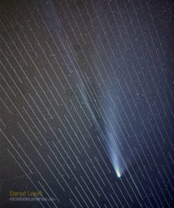
“Comet Neowise has been the brightest and most visible space snowball in a generation, but it’s also the first naked-eye comet to visit us in the new era of satellite mega-constellations like SpaceX’s Starlink,” writes CNET.
“In just the latest episode of Starlink ‘trains’ irritating astronomers, a number of images have been circulating of the satellites photo-bombing Comet Neowise glamour shots…”
Live Science explains: Visible just above the horizon right now, the comet appears faint and small to the naked eye, but can be seen clearly through cameras with long, telephoto lenses. Usually, when photographers capture objects like this in the night sky they use long exposure times, leaving the camera aperture open to collect light over the course of several seconds. But now comet-chasers report that a new fleet of SpaceX’s Starlink satellites is leaving bright smears across their NEOWISE snaps, as the shiny orbiters streak through their frames during long exposures.
The AI that DutchSteamMachine uses is called Depth-Aware video frame INterpolation, or DAIN for short. This AI is open source, free and constantly being developed and improved upon… “People have used the same AI programs to bring old film recordings from the 1900s back to life, in high definition and colour,” he said. “This technique seemed like a great thing to apply to much newer footage….”
DutchSteamMachine does this work in his spare time, and posts it for free on his YouTube page. His tagline is “Preserving the past for the future…” And he’s planning to keep it all coming. “I plan to improve tons of Apollo footage like this,” he said. “A lot more space and history-related footage is going to be published on my YT channel continuously.” He also has a Flickr page with more enhanced imagery. [And a Patreon page…]
Long-time Slashdot reader schwit1 calls it “similar to what Peter Jackson did with old World War I footage for They Shall Not Grow Old.”
The middle kingdom’s previous red planet effort, 2011’s Yinghuo-1, rode on a Russian rocket that failed to leave Earth orbit and therefore did not fulfill its orbital observation mission.
For this new mission, dubbed Tianwen-1, China has used its own Long March 5 heavy lifter and packed in an orbiter, lander and rover.
Chinese State media has confirmed the launch and a People’s Daily social media post includes video of a rocket heading upwards and says it’s Mars-bound.
China’s being typically cagey about the mission, which is believed to plan a landing with a combination of parachutes and airbags before the rover deploys a range of instruments capable of investigating Martian magnetic fields, geology and chemistry. The orbiter packs a camera capable of two-metre resolution from a height of 400kms, plus more magnetosphere-sensing kit.
If the mission succeeds, China will join the USA, Soviet Union, European Union and India as successful sponsors of Mars missions. Only the USA, Soviet Union and EU have landed rovers on the red planet.
The USA and UK have alleged that Russia last week trialled an in-orbit satellite-killer weapon.
US Space Force chief of operations General John Raymond put his name to a statement that says on July 15th Russia “injected a new object into orbit from Cosmos 2543”, a satellite that Moscow insists is a maintenance vehicle but which the USA believes is a weapons platform.
Cosmos 2543 sidled up to another Russian satellite before releasing the object that moved at around 700 km/h.
The UK’s Ministry of Defence popped up a Tweet about the incident:
Air Vice-Marshal @HarvSmyth, director of the UK’s Space Directorate, has responded to a recent Russian satellite test in space: pic.twitter.com/zGdGwCemmR
The Outer Space Treaty prohibits the use of weapons in space, so if Moscow has conducted a weapons test it has been very naughty indeed. However it is widely believed that several nations posses missiles that could reach space to attack satellites.
Such attacks are important because satellite play a significant role assisting and directing terrestrial conflicts.
An international consortium has compiled the most comprehensive 3D map of the observable cosmos to date, significantly improving our understanding of cosmological history while raising new questions about the fundamental laws that govern the universe.
The updated map, made from data gathered by the Sloan Digital Sky Survey (SDSS), offers a detailed history of the cosmos, from the Big Bang and its early expansion phase through to the current era.
The latest phase of the project, called “extended Baryon Oscillation Spectroscopic Survey” (eBOSS), includes the positions and distances of more than 4 million galaxies and ultra-bright quasars surrounding supermassive black holes, according to a press release from EPFL, a Swiss research institute. The new results are showing how the universe evolved over an 11-billion-year period, filling an important gap in our knowledge.
“In 2012, I launched the eBOSS project with the idea of producing the most complete 3D map of the Universe throughout the lifetime of the Universe, implementing for the first time celestial objects that indicate the distribution of matter in the distant Universe, galaxies that actively form stars and quasars,” Jean-Paul Kneib, a co-leader of the project and an EPFL astrophysicist, said in the press release. “It is a great pleasure to see the culmination of this work today.”
The eBOSS project has resulted in 23 new scientific papers (plus the new map), which were released today to the arXiv pre-print server.
Astrophysicists have previously chronicled the earliest days of the universe by calculating the abundance of elements created after the Big Bang and studying the Cosmic Microwave Background Radiation—the cooled remnant of the universe’s first light. Scientists also have a good handle on recent cosmological history, as informed by galactic maps and distance measurements. But “there’s a troublesome gap in the middle 11 billion years,” said Kyle Dawson, a cosmologist at the University of Utah and the principal investigator of eBoss, in an SDSS press release.
To gaze back at this 11-billion-year gap, the scientists honed in on galaxies and quasars, looking for patterns in how they’re distributed across the universe. These observations were then combined with data gathered during previous phases of SDSS, dating back to 1998.
“Taken together, detailed analyses of the eBOSS map and the earlier SDSS experiments have now provided the most accurate expansion history measurements over the widest-ever range of cosmic time,” Will Percival, an astrophysicist at the University of Waterloo and eBOSS’s Survey Scientist, said in the EPFL statement. “These studies allow us to connect all these measurements into a complete story of the expansion of the Universe.”
The updated map shows empty voids and filaments that defined the universe a mere 300,000 years after the Big Bang, which happened 13.8 billion years ago. By identifying ancient quasars—extremely bright galactic cores surrounding supermassive black holes—the researchers were able to map regions more than 11 billion years old. To map more recent periods, namely regions between 6 billion and 11 billion years old, the scientists tracked patterns in the distribution of galaxies, which subsequently enabled more accurate measurements of dark energy.
The United Arab Emirates has successfully launched a Mars probe.
The Emirates Mars Mission (EMM) aims to orbit the red planet with a probe named “Hope” that will gather data to help humanity build a proper Martian weather map, characterise the planet’s lower atmosphere and offer an explanation of why Mars is losing Hydrogen and Oxygen into space.
Early on Monday, Hope was launched atop from Japan’s Tanegashima Space Center atop a Mitsubishi Heavy Industries H-IIA rocket.
Moments that make history… The Emirates Mars Mission team participates in the first Arabic countdown from Japan… The countdown that ushers a new era for Arab space exploration. #HopeMarsMission#HopeProbepic.twitter.com/PaKk75e5F9
— Hope Mars Mission (@HopeMarsMission) July 19, 2020
The mission appears to be in fine shape, as just a few hours after launch the probe was beaming back a signal.
— Hope Mars Mission (@HopeMarsMission) July 20, 2020
Now comes the seven-month schlep to the Red Planet. On arrival Hope will conduct a 30-minute burn to slow itself from over 121,000 km/h to approximately 18,000 km/h. At the latter speed, Mars’ gravity should be sufficient to see the probe enter an orbit with a perigee that sometimes falls beneath 1,000km. Further operations will aim to settle the craft into its planned orbit for doing science, with a perigee and apogee of between 20,000km and 43,000km.
From that orbit Hope will use its infrared and ultraviolet spectrometers, plus a 4:3 visible-spectrum imager packing a 12-megapixel 12-bit monochrome CMOS array, to gather data on Mars’ atmosphere. The probe will contact Earth twice a week for sessions lasting between six and eight hours. Mission scientists expect around one terabyte of data to flow during those connection windows and have planned for the probe to operate for two years.
Hope’s scientific payload is modest compared to NASA’s MAVEN or India’s Mangalyaan, but the mission is significant as it is the first interplanetary effort mounted by an Arab nation. As such it is the source of considerable pride.
On Sunday morning, local time in New Zealand, Rocket Lab launched its 13th mission. The booster’s first stage performed normally, but just as the second stage neared an altitude of 200km, something went wrong and the vehicle was lost.
In the immediate aftermath of the failure, the company did not provide any additional information about the problem that occurred with the second stage.
“We lost the flight late into the mission,” said Peter Beck, the company’s founder and chief executive, on Twitter. “I am incredibly sorry that we failed to deliver our customers satellites today. Rest assured we will find the issue, correct it and be back on the pad soon.”
The mission, dubbed “Pics Or It Didn’t Happen,” carried 5 SuperDove satellites for the imaging company Planet, as well as commercial payloads both for Canon Electronics and In-Space Missions.
“The In-Space team is absolutely gutted by this news,” the company said after the loss. Its Faraday-1 spacecraft hosted multiple experiments within a 6U CubeSat. “Two years of hard work from an incredibly committed group of brilliant engineers up in smoke. It really was a very cool little spacecraft.”
Before this weekend’s failure, Rocket Lab had enjoyed an excellent run of success. The company’s first test flight, in May 2017, was lost at an altitude of 224km due to a ground software issue. But beginning with its next flight, in January, 2018, through June, 2020, the company had rattled off a string of 11 successful missions and emerged as a major player in the small satellite launch industry. It has built two additional launch pads, one in New Zealand and another in Virginia, U.S., and taken steps toward reusing its first stage booster.
It seems likely that Rocket Lab will make good on Beck’s promise to address this failure and return to flight soon. His was the first commercial company in a new generation of small satellite rocket developers to reach orbit, and even now remains the only one to do so. Other competitors, including Virgin Orbit, Astra, and Firefly may reach orbit later this year. But Rocket Lab has plenty of experience to draw upon as it works to identify the underlying problem with its second stage, and fix it. There can be little doubt they will.
Russia’s space agency Roscosmos has re-entered the space tourism market and this time will offer one person the chance to spacewalk.
The agency on Thursday announced a new deal with US outfit Space Adventures to take two people to the International Space Station atop a Soyuz rocket. One of the tourists, according to Space Adventures’ announcement, “will have an opportunity to conduct a spacewalk outside the space station, becoming the first private citizen in history to experience open space.”
The spacewalking tourist will be accompanied by a professional Russian cosmonaut.
The two companies have previously launched seven space tourists including Ubuntu daddy Mark Shuttleworth in 2002. Your correspondent interviewed him about the experience in 2005 and he was still clearly awed by the power of the Soyuz, weightlessness and the views from above, to the extent that he said a sub-orbital tourist flight with the likes of Virgin Galactic held little appeal.
The trip will see the pair of tourists spend 14 days in the Russian module of the ISS.
China sent the last satellite to space on Tuesday to complete its global navigation system that will help wean it off U.S. technology in this area.
The network known as Beidou, which has been in the works for over two decades, is a significant step for China’s space and technology ambitions.
Beidou is a rival to the U.S. government-owned Global Positioning System (GPS), which is widely-used across the world.
Experts previously told CNBC that Beidou will help China’s military stay online in case of a conflict with the U.S. But the launch is also part of Beijing’s push to increase its technological influence globally.
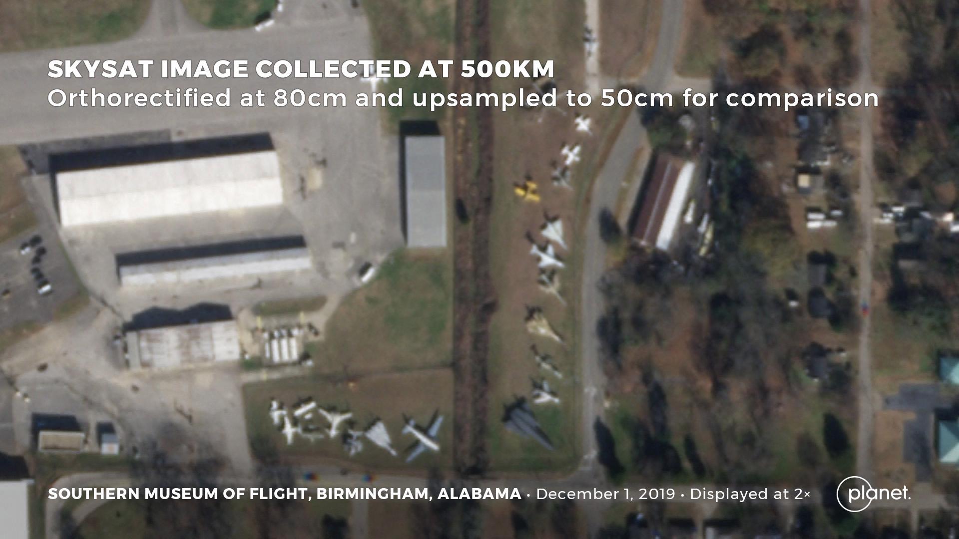
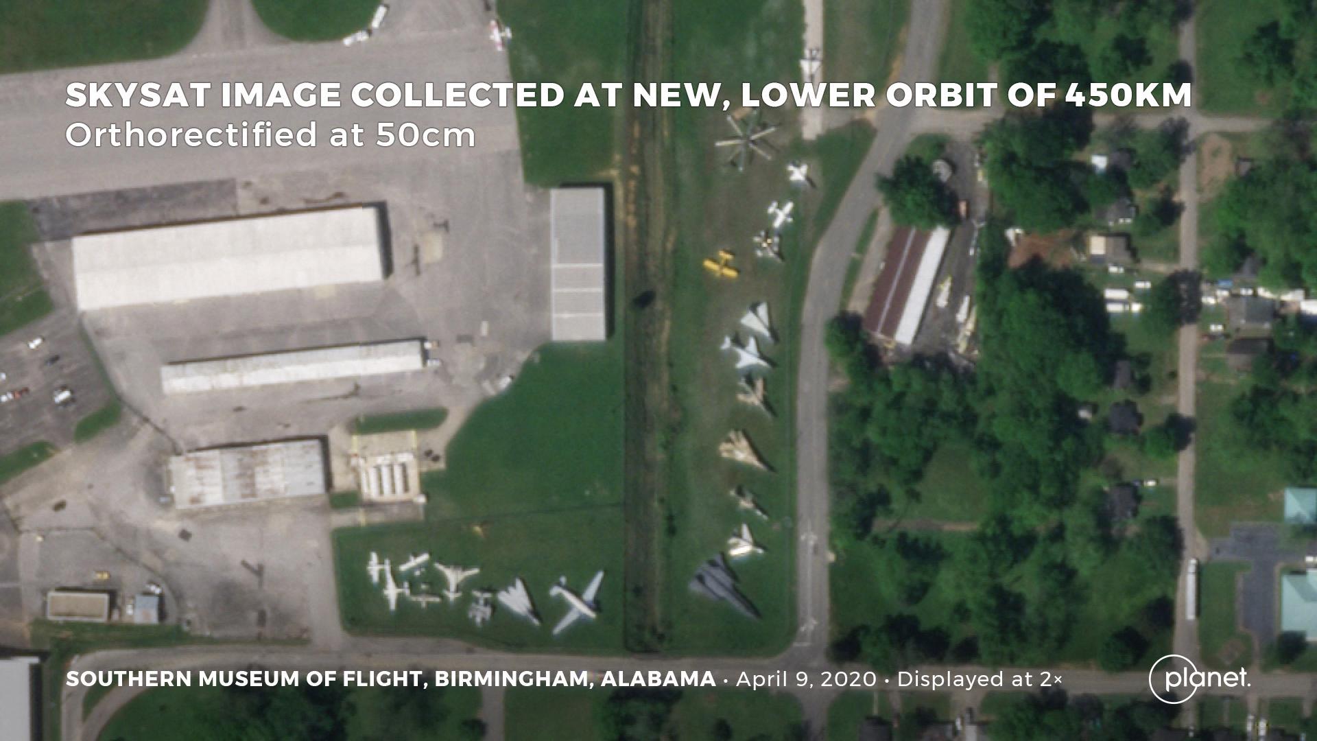
The remote-sensing firm Planet operates more than one hundred satellites that constantly orbit the earth, collecting imagery of the world’s entire landmass each day. Now, to offer more clarity to its customers, it has flown a handful of its satellites 50 km closer to the Earth.
This literal zoom-in effort will allow the firm to offer imagery with a resolution of 50 cm of earth per pixel, an increase from 80 cm. In one example, that means that as well as seeing the shape of a car, analysts will also be able to clearly discern the position of its windshield.
By the end of the summer, the company plans to add six new satellites to its constellation, allowing it to take those higher resolution pictures of the same area twelve times a day.
“We felt like 50 centimeters was an important threshold, but where we are really pushing the envelope is on that revisit,” Jim Thomason, a Planet vice president, told Quartz.
The ability to view the same area repeatedly means customers will get their imagery sooner after they request it, and they may be able to see what is changing on the ground. That also means a higher chance of dodging the bane of optical space imagery: clouds.
Planet
A “before” image.
An “after” image. “Orthorectified” refers to the process where sensor data taken of uneven terrain is accurately mapped onto a flat image.
Planet was founded in 2010 by former NASA scientists who wanted to leverage new advances in satellite technology and expand access to space data. Its customers include US intelligence agencies, the NGOs that second-guess them, agricultural conglomerates, and firms that use machine learning to gain insight from remote-sensing data.
Planet operates more than 150 satellites, most of which are Doves, toaster-oven sized craft that collectively “scan” the earth each day, producing imagery with a resolution about three meters per pixel. You may have seen the company’s widely-shared image of a new mural in Washington, D.C.